
![Nantahala and Cullasaja Gorges Map [Nantahala National Forest] (National Geographic Trails Illustrated Map, 785)](https://kelantravels.com/wp-content/uploads/2025/08/nantahala-and-c_0.jpg)
![Nantahala and Cullasaja Gorges Map [Nantahala National Forest] (National Geographic Trails Illustrated Map, 785) - Image 2](https://kelantravels.com/wp-content/uploads/2025/08/nantahala-and-c_1.jpg)
![Nantahala and Cullasaja Gorges Map [Nantahala National Forest] (National Geographic Trails Illustrated Map, 785) - Image 3](https://kelantravels.com/wp-content/uploads/2025/08/nantahala-and-c_2.jpg)
![Nantahala and Cullasaja Gorges Map [Nantahala National Forest] (National Geographic Trails Illustrated Map, 785) - Image 4](https://kelantravels.com/wp-content/uploads/2025/08/nantahala-and-c_3.jpg)
![Nantahala and Cullasaja Gorges Map [Nantahala National Forest] (National Geographic Trails Illustrated Map, 785) - Image 5](https://kelantravels.com/wp-content/uploads/2025/08/nantahala-and-c_4.jpg)
![Nantahala and Cullasaja Gorges Map [Nantahala National Forest] (National Geographic Trails Illustrated Map, 785) - Image 6](https://kelantravels.com/wp-content/uploads/2025/08/nantahala-and-c_5.jpg)
![Nantahala and Cullasaja Gorges Map [Nantahala National Forest] (National Geographic Trails Illustrated Map, 785) - Image 7](https://kelantravels.com/wp-content/uploads/2025/08/nantahala-and-c_6.jpg)
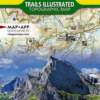
Nantahala and Cullasaja Gorges Map [Nantahala National Forest] (National Geographic Trails Illustrated Map, 785)
€14.95
17 in stock
Explore the stunning Nantahala and Cullasaja Gorges with the detailed and informative National Geographic Trails Illustrated Map, 785. This topographic map is your essential guide to the rugged terrain and lush forests of the Nantahala National Forest in North Carolina.
Discover over 500 miles of trails for hiking, biking, and horseback riding, including the iconic Appalachian Trail and Bartram Trail. Navigate the numerous waterways, including the Nantahala River and Lake Glenville, for fishing, kayaking, and scenic views.
With accurate topography, trail mileage, and points of interest marked, this map is perfect for outdoor enthusiasts, hikers, campers, and nature lovers looking to explore the beauty of Nantahala and Cullasaja Gorges. Plan your next adventure with confidence using the National Geographic Trails Illustrated Map, 785.
Related products
-
-
Sale!
LandAirSea 54 GPS Tracker – Made in the USA from Domestic & Imported Parts. Long Battery, Magnetic, Waterproof, Global Tracking. Subscription Required
Original price was: €29.95.€14.95Current price is: €14.95. -
Sale!
Glacier and Waterton Lakes National Parks Map (National Geographic Trails Illustrated Map, 215)
Original price was: €14.95.€11.80Current price is: €11.80.
 GPS Navigation for Car,Latest 2025 Map, 7 inch Touch Screen Real Voice Spoken Turn-by-Turn Direction Reminding Navigation System for Cars, GPS Satellite Navigator with Free Lifetime Map Update
  Wired GPS Tracker for Vehicles, No Monthly Fee, No Subscription, 4G SIM and Data Included, Mileage Tracking, Business Fleets, Quick Install, Speeding Alerts, Trip History, USA Developed, Moto Watchdog
  Coleman Kompact 20°F/30°F/40°F Sleeping Bag, Cool-Weather Adult Sleeping Bag with Heat Retention, Stuff Sack, & Snag-Free Zipper, Great for Camping, Sleepovers, Guests & More
  3 Person Camping Chairs Folding Double Camping Chair Portable Oversized Loveseat Padded Camp Chair Heavy Duty Camping Couch for Adults Outdoor Lawn with Two Cup Holders and Carry Bag